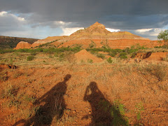
Refresher: We're climbing the Northeast Ridge of Bugaboo Spire. Will takes the first pitch, and it is fantastic. Allison takes the second, pausing for one of our best climbing photos ever:
 We continue to swing leads, and the climbing continues to be fantastic. The clouds build a little more, but most of the time seem to dissipate before passing over the sun, keeping us quite comfortable. We simulclimb part of the easy chimneys, probably around pitch 7. Somewhere in this area 2 guys pass us at breakneck pace, and continue to simulclimb most of the route. They are cruising it.
Allison stops to apply a Band-Aid, way up in space:
 A photo we took of the ridge from the top of the previous day's climb shows 2 climbers at about our current position. They are almost dead center in the photo, on a large ledge on the ridge. If you click on the photo you'll be taken to the photo on Flickr, and from there you can look at a larger size:
 We thought we were high when we topped out yesterday's route, "The Ears Between", but we are only half way up Bugaboo Spire, and the summits of The Donkey's Ears are way, way below us. This thing is tall.
Nearing the top, on the 10th pitch:
 Bugaboo Spire has 2 summits. On our route, you get very near the North Summit on the 10th pitch, do a short rappel, and then a short scramble gets you to the top. You then do an easy but incredibly exposed traverse to the South Summit, about 100 meters away, and just 21 feet higher. We get sucked in to following a party that has passed us somewhere on the route, and Will suspects that it is the wrong way, (confirmed later, at the hut), but we get there nonetheless, it just takes a little longer than it should.
Signing the Summit Register. This climb adds to the short list of summits that we've visited that can only be reached by 5th class (technical rock climbing):
 Among lots of other information, Rob and Mark had informed us that the descent was really involved, and took just as long as the climb. They weren't lying. It involves 5 rappels, mixed with tons and tons of downclimbing and scrambling along the Kain Route, and people have gone every possible way many many times, so the best route is entirely less than obvious. On the Mountain Project page for this route, there is a comment at the bottom that reads: "People will tell you to do the Kain route before the NE ridge, so you are familiar with the descent. The party we met who ignored this advice and wound up spending 2 nights on the spire can confirm that this is good advice." Ouch. Miserable. We find our way, although at times it is clearly not the best way, and finally wind up back at the Kain Hut at about 8:15, almost 16 hours after leaving, feeling enormously satisfied. We are met with congratulations from the folks at the hut who knew we were up there, some of whom followed our progress with a spotting scope. We have some dinner, and the last of our beers, and hit the hay. There is a reason that this route is included in "50 Classics".
July 14, 2008
Time to pack up and head out of the Bugaboos. We say our goodbyes and depart from the Kain Hut. After three days of intense climbing and hiking, the hike down is not as easy as we had hoped. But, we make it down without any problems, and the chicken wire appears to do it's job- no eaten tires.
Upon arrival on paved road, we immediately head south to Radium Hot Springs, a tourist trap ("one of the armpits of civilization" - Will), but nonetheless quite a pleasant experience. We're not quite sure if the heated pool is really heated by a natural spring or just by man, but it feels good on our thrashed bodies either way. After leaving the hot springs, we head back to Golden to find that our computer has not been fixed, and then drive up to Kicking Horse Ski Resort. We entertain the idea of hanging out in the area for a night and then doing a little downhill biking, but instead decide to head back into Yoho National Park and camp again at Chancellor Peak Campground.

July 15, 2008
We wake to a lazy day of driving and sight-seeing with limited walking. Our first stop is at Takakkaw Falls, (or Takakakaka Falls as Cheryl pronounced it), said to be one of the highest waterfalls in Canada, it was worth the short walk that it took to check it out. What was most interesting was how much water was falling since you could not actually see the glacier from which it was flowing.

Our second tourist stop was the Spiral Tunnels. When the Canadian Pacific Railroad first cut its way through the Canadian Rockies, the slope of the railway was so steep that trains were often flying off the rails. Therefore, spiral tunnels were built where the train would circle back on itself as it made it's way down the mountain. We stopped and waited with many others for the train to come through. It was interesting to see the train circle through the tunnels- plus, it did not require any hiking or exertion of any kind.

We departed Yoho National Park and headed into Banff National Park. We visited the park five years ago for our friends Tara and Brian's wedding, so we knew what to expect with the frenzy of tourists. We made a few quick stops and then headed off to find a campspot.
July 16, 2008
Our main goal in Banff is to climb Eeyore's Tail on Mount Rundle, just outside of Banff. Yet, we still need a day or two to recover from the Bugaboos, so we decide to take a hike, recommended by Will's mom, Jamie, to check out the Teahouses around Lake Louise . The hike took us up to the first teahouse at Lake Agnes, about 3.4 km. Then we took off to check out the view from the Big Beehive, about 1.6 km further. At the lookout we ran into some folks with a map that showed that we were, in fact, on a trail that would take us to the second teahouse. So, off we went to the Point of Six Glaciers Teahouse. It's a beautiful little structure where they make fresh scones and bread and serve hot tea. So, we partake of hot tea and a delicious scone before making our way back to the madness of Lake Louise. In total we think that we probably covered about 13 km, some of it quite steep. It was nice not to be carrying huge backpacks, and we feel that our time climbing and hiking at altitude with heavy loads has helped our endurance.

Upon arriving back at the Chateau Lake Louise, Will spots Rob and Mark, two climbers that we met at the Kain Hut. They had decided to leave the hut a day early and had spent the day climbing at Lake Louise. They are staying in Banff for the night with another climber that they met at the hut, Kris, so we decide to all meet up for dinner. We grab dinner at the St. James Gate Olde Irish Pub and get beta from Kris for a local route to climb tomorrow as the weather does not appear to be ideal for Eeyore's Tail.
July 17th, 2008
We sleep in again, and awake to crystal clear skies at 10 am. Immediately we wish we'd done Eeyore's Tail today, but it's too late to start now. We breakfast at the cafe at the YWCA Mountain Lodge, where we'd stayed years before for Tara and Brian's wedding. This is the same cafe we ate in on the morning that we had our epic on Eeyore's. After breakfast we park near the trailhead for Tunnel Mountain. A short hike brings us to the base of the route. If this were in Atlanta, it would be a destination crag. It sits smack in Banff though, and judged on that scale, it is sort of a turdpile. Will is feeling incredibly lethargic and unmotivated. We hike out. We will take it easy in Banff today, and fire up Eeyore's Tail tomorrow. And so that brings us to the Internet Underground, where we sit now.
More later,
A & W
1 comment:
Wow. Without sounding too much like a big sister... wow, nice work Allison (you too Will). Awesome photography - thanks for keeping the blog updated. What amazing views. Be safe. We love you guys.
Post a Comment