Sunday, July 27, 2008

Everything Else

July 18th, 2008

Wow, so it's been awhile! Logistically, blogging became much more difficult after the laptop fried...

When we last left our heroes they were lazing around Banff on what would've been a perfect day to climb Eeyore's Tail, with plans to hit it the next day (today). Well, it rained intermittently all night (of course), and at 4 am, the alarm sounded in perfect sync with booming thunder, and it started raining harder (of course). We killed the alarm and rolled over. In the planning stages of this trip, we knew we'd be visiting a lot of places that are famous for finicky weather, but we thought that Banff would be the least finicky. Too many rest days. Too much sitting around. Getting antsy. End of vacation looming closer. Gotta move.

We decide "to hell with Eeyore's Tail". The route isn't known to be fantastic anyway, and the only reason we're doing it is to redeem ourselves from our epic years ago, which certainly we've done, if not on the same route. We decide to blast east to Yamnuska, a huge cliff just west of Calgary. The weather is known to get better as you head east. But (of course), when we arrive, the cliff is shrouded in dark grey clouds. It looks like an awesome place to climb, but right now it looks very cold. Clearly there are a number of forces working in concert here, the net result being a negative effect on our motivation level. They are:

The weather (of course)
Our time allowance in days (it's dwindling, we're antsy)
The fact that we've gotten A LOT of climbing in already (satiation, complacency)
The fact that we've gotten A LOT of climbing in already (we're tired)

So with some misgivings, we turn southward, toward the U. S. A. (God Bless It). 

On the recommendation of Cheryl, the Kain Hut Custodian, we drive through Kananaskis Country, on the eastern border of the mountains. It is beautiful. We enter into Montana through a customs gate at high altitude that's only open in summer. Immediately we miss the metric system. In Canada when a sign says that your destination is 100 km away, you're there in virtually NO TIME, since you're programmed in MILES. Upon reentry, we jokingly remarked "Now it's gonna take FOREVER to get anywhere." Yes, of course we realize that this would wear off if we spent lots of time in Canada...

We drive through Glacier National Park, also amazing in its beauty, but a bit of a pain owing to lots of roadwork. Another twist on the kiteboarding theme -- near the center of the park, someone is kiteboarding on a glacier, with a snowboard.

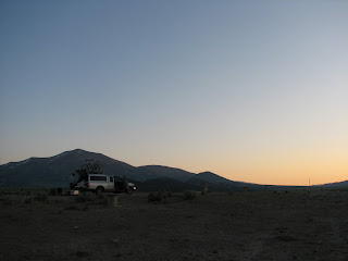
We continue southward, passing so many familiar icons of our country. Wal-Mart. Applebees. Office Depot. Just to assure ourselves that we've returned to The States, we stop in Polson and each eat a HUGE plate of bad mexican food, which we immediately regret. We camp on the side of a road on National Forest land, just east of Missoula.

July 19th, 2008

We decide today that we'll head to Devil's Tower (and climb it this time), then The Needles, in the Black Hills, so we need guidebooks for each, which we'll pick up in Bozeman. On the way there we take a break from the interstate on a scenic highway, which takes us through the charming old west town of Anaconda. We both realize that we'll never be able to see or hear that word again without thinking of Sir-Mix-A-Lot. We cruise into the lovely Bozeman, and all of the downtown retailers have the sidewalks filled with sale items. We grab our guidebooks at the local climbing store and notice (inside joke here) that Chris Sierzant is on the cover of the current edition of Urban Climber. We blast for Devil's Tower, arriving at about 9 pm and, once again, snag one of the last campsites. At about 10 we notice headlamps on the tower. A party of 2 is slowly descending.

July 20th, 2008

We rise at 5:20 am, eager to beat the heat and the crowds. We'd attempted The Tower on our very first road trip, in June of '03, but due to bad timing and route selection, we'd pretty much been baked off the rock, and left frustrated. On the way here yesterday, we'd decided on the Durrance Route, (5.6) which would mean our second climb from "50 Classic Climbs in North America" in less than a week. You have to register to climb here, and register your return (for safety reasons).  In the climbing office we find out that the Durrance Route is closed for raptor nesting. Many climbs throughout the nation are closed from spring through mid-summer if raptors have chosen to nest there. They generally reopen when the young birds fly the coop. As an alternative we choose "Bon Homme" with the "Horning Variation" (5.8). Will leads pitch 1, Allison pitch 2, and we simulclimb the summit pitch. The route is fine, but a bit of a grunt. Remind me to lie back the first pitch next time instead of jamming. It is excellent and redeeming to summit the tower finally. We spend some time on top, take a few photos, then rappel. It is clear that the rappel route is set up for single rope rappels, and when we see this we should know better than to be greedy and do double-rope raps, but we do it anyway, and of course, pulling our ropes from the last rappel they get stuck. We do have one whole rope though, so Will leads the first half of the first pitch, up to the last rap anchor (which we'd skipped in our greed), frees the rope, and rappels down. At least it was the fun part of the pitch, and not the grunty part.

Hiking out, we encounter some obvious climbers hiking in, and we all stop and chat. We find out that one of them is Frank Sanders, who, on July 3rd, wrapped up a charity campaign which entailed summitting The Tower every day for 365 days in a row. Imagine doing this in winter. Brutal. We totally cheese out and ask him to pose for a photo with us. Then we hit the road for The Needles.
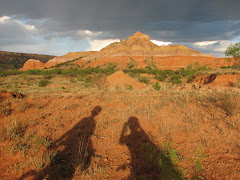
The Needles consist of tall, thin granite spires, some over 200 feet, with summits that are barely big enough for one person to sit on.
They're located in Custer State Park, in the Black Hills, in the southwest corner of South Dakota. They're known for a strict bolted-on-lead (runout) ethic, so much of the climbing here is very bold. The park itself is mostly unspoiled, aside from the work of the same pine beetle that wreaks havoc at home in the southeast. It is loaded with tourists sightseeing. They are fascinated by the rocks, and even more fascinated by the climbers. Much of the surrounding area is a cheesy wild-west tourist wonderland (more water slides, mini-golf, dinosaur and fossil exhibits, sad petting zoos, gift shops, the whole gamut). Presumably it all developed as a side attraction to nearby Mt. Rushmore. We establish camp at Stockade Lake Campground.

July 21st, 2008

We set our sights on a group of rocks called the Cathedral Spires, and the Cathedral Enchainment (5.9), which includes tagging 3 tiny summits with some rappelling in between, but never to the ground. It also involves a 25 minute approach, which we mess up initially, but eventually we find the start of the route, at the first spire, West Gruesome (5.7). Cool route, which we climb in 2 pitches, and sign the summit register.
A huge, menacing cloud is rolling in though, and we decide to bail, at least temporarily. Will rappels down, and as Allison starts rapping, it begins to rain. We find a convenient little cave in which to hunker down and eat some lunch, as it rains and hails. The rain stops, and we emerge, but the clouds don't look much better, and the rock is wet, so we hike out. We are glad to have tagged one tiny summit anyway...

We drive to a very popular sightseeing spot, the Needle's Eye area, named such because a massive tower right beside the road separates into two, then rejoins up high, creating a huge needle's eye. There we encounter some Needles regulars, one of whom is pictured and discussed in our guidebook, prolific Needles first ascensionist John Biddick. The weather clears, and we follow them back to some climbs a short bit from the road. We climb Obstacle Course (5.10b), on some unknown formation, then the Direct Route (5.8) up The Gnomon.

July 22nd, 2008

We return to the Needle's Eye area, and climb Threading The Needle, which of course entails climbing right through the giant Needle's Eye.
Will leads, with the spectacular 9+ finish. Then we toprope the 5.10 on the front of the formation, leaning on the front of the truck as we belay each other. We answer tons of questions from the sightseers, the most popular of which is, of course, "How'd you get that rope up there?". We relocate to the Ten Pins area and finish our Needles experience with the classic tall, thin spire, Tricouni Nail (5.8). There is no anchor at the top -- you merely pass your rope between two bulbous "heads" on the summit, and simul-rappel off of opposite sides. This results in a classic needles photo op (thanks Peggy!):
We pack up and head toward The Badlands, pausing to view Mt. Rushmore from the road (which is surreal).

We camp at the Sage Creek Campground, in the middle of nowhere in Badlands National Park. There is very little infrastructure here, and what little there is is well-preserved from the 50's or 60's. It truly felt like we were in a period movie, a feeling that was supported by the fact that all the way out the long dirt road to get here we were following a 1938 Dodge coupe (now parked at a campsite a few hundred feet from us). This is a beautiful place. We shoot at least 100 photos in this campground alone. Gotta love digital.
July 23rd, 2008

We continue through The Badlands, then make the uneventful drive to Minneapolis, where we visit Janna, a college friend of Allison's. We arrive at Janna's D & B & B (Dinner AND Bed AND Breakfast) where we finally get to meet her four precious girls- Quinn, Gillian, Aubrey, and Shelby. Janna treats us to an amazing dinner- she should go into the hospitality business.
July 24th, 2008

This morning we wake up and hang out with Janna and her girls for a little while before hitting the road. We get to see a little of Minneapolis by taking a walk around Lake Harriet, one of the lakes in the Chain of Lakes. We grab lunch in a great little neighborhood and then head out of town. Thanks for the great visit, Janna and family!

We arrive at our chosen campground at the Starved Rock Campground in Illinois only to find it full. So, this will be our first night out of the whole trip where we end up crashing at a hotel- not really even a hotel, we stay at the Starved Rock State Park Lodge.

July 25th, 2008

The rest of the trip home is pretty uneventful aside from a quick stop in St. Louis to pick up a kayak that we bought off of Craigslist before we left town in June. We stay at a hotel again on our last night, because driving way off of the interstate late at night, only to find a state campground full or full of mosquitoes seems awful. We just want to get home. We DO miss the bed setup in the back of the truck though. It was truly the most comfortable place we slept for the entire trip.

July 26th, 2008

We make it home. Yep, here we are back in Atlanta. And, it is hot. But it does look like we've had some rain, so maybe it won't be quite as bad as last summer. The trip ends with cooking out and a movie at the Starlight Six drive-in down the street with some friends. A good way to wrap up the trip...back in Atlanta with our friends. Also, we were able to hook the semi-dead laptop to another machine and pull off all of the photos that we thought might be permanently lost. A new photo posting of those can be found in this set.

We'll be posting some videos on our flickr site soon.

Random notes, July 27th, 2008:

We drove a grand total of 7,765 miles. This may seem silly with current gas prices, but for perspective, we spent less on gas on this entire trip than we spent 5 years ago for our plane tickets to Banff alone, and we experienced SO much, in SO many places. We'd have happily paid double. We had a self-prescribed speed limit of 65, which saved a lot of gas, and possibly speeding tickets. It is nice to be home, but certainly that feeling will be short-lived.

A & W


Thursday, July 17, 2008

Bugaboos (Cont.) to Canadian Rockies

July 13th, 2008 (continued)

Refresher: We're climbing the Northeast Ridge of Bugaboo Spire. Will takes the first pitch, and it is fantastic. Allison takes the second, pausing for one of our best climbing photos ever:
We continue to swing leads, and the climbing continues to be fantastic. The clouds build a little more, but most of the time seem to dissipate before passing over the sun, keeping us quite comfortable. We simulclimb part of the easy chimneys, probably around pitch 7. Somewhere in this area 2 guys pass us at breakneck pace, and continue to simulclimb most of the route. They are cruising it.

Allison stops to apply a Band-Aid, way up in space:

A photo we took of the ridge from the top of the previous day's climb shows 2 climbers at about our current position. They are almost dead center in the photo, on a large ledge on the ridge. If you click on the photo you'll be taken to the photo on Flickr, and from there you can look at a larger size:
We thought we were high when we topped out yesterday's route, "The Ears Between", but we are only half way up Bugaboo Spire, and the summits of The Donkey's Ears are way, way below us. This thing is tall.

Nearing the top, on the 10th pitch:

Bugaboo Spire has 2 summits. On our route, you get very near the North Summit on the 10th pitch, do a short rappel, and then a short scramble gets you to the top. You then do an easy but incredibly exposed traverse to the South Summit, about 100 meters away, and just 21 feet higher. We get sucked in to following a party that has passed us somewhere on the route, and Will suspects that it is the wrong way, (confirmed later, at the hut), but we get there nonetheless, it just takes a little longer than it should.

Signing the Summit Register. This climb adds to the short list of summits that we've visited that can only be reached by 5th class (technical rock climbing):

Among lots of other information, Rob and Mark had informed us that the descent was really involved, and took just as long as the climb. They weren't lying. It involves 5 rappels, mixed with tons and tons of downclimbing and scrambling along the Kain Route, and people have gone every possible way many many times, so the best route is entirely less than obvious. On the Mountain Project page for this route, there is a comment at the bottom that reads: "People will tell you to do the Kain route before the NE ridge, so you are familiar with the descent. The party we met who ignored this advice and wound up spending 2 nights on the spire can confirm that this is good advice." Ouch. Miserable. We find our way, although at times it is clearly not the best way, and finally wind up back at the Kain Hut at about 8:15, almost 16 hours after leaving, feeling enormously satisfied. We are met with congratulations from the folks at the hut who knew we were up there, some of whom followed our progress with a spotting scope. We have some dinner, and the last of our beers, and hit the hay. There is a reason that this route is included in "50 Classics".

July 14, 2008

Time to pack up and head out of the Bugaboos. We say our goodbyes and depart from the Kain Hut. After three days of intense climbing and hiking, the hike down is not as easy as we had hoped. But, we make it down without any problems, and the chicken wire appears to do it's job- no eaten tires.

Upon arrival on paved road, we immediately head south to Radium Hot Springs, a tourist trap ("one of the armpits of civilization" - Will), but nonetheless quite a pleasant experience. We're not quite sure if the heated pool is really heated by a natural spring or just by man, but it feels good on our thrashed bodies either way. After leaving the hot springs, we head back to Golden to find that our computer has not been fixed, and then drive up to Kicking Horse Ski Resort. We entertain the idea of hanging out in the area for a night and then doing a little downhill biking, but instead decide to head back into Yoho National Park and camp again at Chancellor Peak Campground.

July 15, 2008

We wake to a lazy day of driving and sight-seeing with limited walking. Our first stop is at Takakkaw Falls, (or Takakakaka Falls as Cheryl pronounced it), said to be one of the highest waterfalls in Canada, it was worth the short walk that it took to check it out. What was most interesting was how much water was falling since you could not actually see the glacier from which it was flowing.

Our second tourist stop was the Spiral Tunnels. When the Canadian Pacific Railroad first cut its way through the Canadian Rockies, the slope of the railway was so steep that trains were often flying off the rails. Therefore, spiral tunnels were built where the train would circle back on itself as it made it's way down the mountain. We stopped and waited with many others for the train to come through. It was interesting to see the train circle through the tunnels- plus, it did not require any hiking or exertion of any kind.


We departed Yoho National Park and headed into Banff National Park. We visited the park five years ago for our friends Tara and Brian's wedding, so we knew what to expect with the frenzy of tourists. We made a few quick stops and then headed off to find a campspot.

July 16, 2008

Our main goal in Banff is to climb Eeyore's Tail on Mount Rundle, just outside of Banff. Yet, we still need a day or two to recover from the Bugaboos, so we decide to take a hike, recommended by Will's mom, Jamie, to check out the Teahouses around Lake Louise . The hike took us up to the first teahouse at Lake Agnes, about 3.4 km. Then we took off to check out the view from the Big Beehive, about 1.6 km further. At the lookout we ran into some folks with a map that showed that we were, in fact, on a trail that would take us to the second teahouse. So, off we went to the Point of Six Glaciers Teahouse. It's a beautiful little structure where they make fresh scones and bread and serve hot tea. So, we partake of hot tea and a delicious scone before making our way back to the madness of Lake Louise. In total we think that we probably covered about 13 km, some of it quite steep. It was nice not to be carrying huge backpacks, and we feel that our time climbing and hiking at altitude with heavy loads has helped our endurance.

Upon arriving back at the Chateau Lake Louise, Will spots Rob and Mark, two climbers that we met at the Kain Hut. They had decided to leave the hut a day early and had spent the day climbing at Lake Louise. They are staying in Banff for the night with another climber that they met at the hut, Kris, so we decide to all meet up for dinner. We grab dinner at the St. James Gate Olde Irish Pub and get beta from Kris for a local route to climb tomorrow as the weather does not appear to be ideal for Eeyore's Tail.

July 17th, 2008

We sleep in again, and awake to crystal clear skies at 10 am. Immediately we wish we'd done Eeyore's Tail today, but it's too late to start now. We breakfast at the cafe at the YWCA Mountain Lodge, where we'd stayed years before for Tara and Brian's wedding. This is the same cafe we ate in on the morning that we had our epic on Eeyore's. After breakfast we park near the trailhead for Tunnel Mountain. A short hike brings us to the base of the route. If this were in Atlanta, it would be a destination crag. It sits smack in Banff though, and judged on that scale, it is sort of a turdpile. Will is feeling incredibly lethargic and unmotivated. We hike out. We will take it easy in Banff today, and fire up Eeyore's Tail tomorrow. And so that brings us to the Internet Underground, where we sit now.

More later,

A & W

Tuesday, July 15, 2008

Bugaboos!

July 9, 2008

Last night we drove into Yoho Provincial Park, and camped at the beautiful Chancellor Campground. The trains passing right next to us only woke us for a few minutes throughout the night : ).

July 10, 2008

After breakfast we drove east for a brief visit to the Yoho Visitor's Center, then headed back west and south to the Bugaboos. This is a really high commitment undertaking. First, you drive a rough dirt logging road for about 46 km. Then you have to porcupine-proof your car. There are porcupines in the area that love to eat rubber, and they will eat all of the rubber parts of your car -- hoses, bushings, even the tires. At the parking, there is a corral filled with rolls of chicken wire. You basically wrap the base of your car with the chicken wire, place rocks on the base of the wire, and lean short pieces of wood on the top to keep it all in place.Then you have to figure out how to pack all of your climbing gear, clothing, sleeping bag, and food for the duration of your stay, and keep it light enough to do the 3-hour, 2400 meter elevation gain hike to the Kain Hut. When packing for the road trip, we'd made the decision to leave our bigger packs at home. We regret this now. We had several climbing objectives here, and as the weather is very finicky, we planned to stay for 5 days. I have to put all of the food, and the 2 six packs of beer into a day pack, and strap that to the top of my crag pack. (We're only bringing the essentials). After a lot of gear and food sorting, we begin the trudge. It is a well-maintained trail, but the load on your back makes it arduous.

You have to keep reminding yourself that it will be well worth it. A few minutes into the hike it starts to rain lightly. It stops after a while, then when we are nearing the Conrad Kain Hut, it begins to snow. When we finally arrive, it's snowing quite hard, and collecting on the trees. I'm not sure if I've ever been so happy to walk into a door. Removing my pack is heavenly, but with the snow we wonder if we'll get any climbing in. Many people visit the Bugaboos several times without ever getting to climb. The weather is notorious.

For being in the alpine backcountry, the Kain Hut is quite posh. Clean running water from the glaciers above, electricity, stoves, padded sleeping bunks, and places to hang climbing gear to dry, with heaters below the hangers. The Applebee Campground lies another 45 minutes up the trail, and gets you that much closer to the climbs, but of course requires bringing a tent, stove, and sleeping pads, and if the weather is nasty, the Kain Hut is a much better place to be.

Dining area at Kain Hut, snowing hard outside:


We stake out our place in the bunks, prepare dinner, and chat with other climbers about the various routes they've done, and the logistics involved. We meet a guy named Rob from Knoxville, TN, and his partner Mark, from Salt Lake City. Rob climbs at a lot of the same places in the southeast that we climb. He and Mark are half way through a 10 or so day stay here, and are knocking off all kinds of classic climbs. We pump them for all kinds of info. It is still snowing hard, and collecting. Cheryl, the friendly and informative hut custodian, gets the forecast via 2-way radio or satellite phone at 9 pm every day, and it calls for 0% chance of precipitation tomorrow. If all of the routes aren't covered in snow, we may just get some climbing in.

July 11th, 2008

We sleep in, hoping to let the rock melt and dry, and to recover from lugging our loads up here. One of the climbs on our tick list is McTech Arete, a 5.10- on Crescent Spire that's not extremely tall (about 185 meters), and has a somewhat shorter approach (a little over an hour). Other climbers tell us that it will be one of the fastest routes to dry as well, so we decide to go have a look.

We stomp up the trail, periodically crossing snow. The weather is slightly more reliable here in August, but at that point the snow has melted enough to create serious crevasse danger. We arrive at the route, and it looks dry, so we rack up. Allison takes the first 5.9 pitch, and takes a nice whipper at the crux, then sends it handily. From there we alternate leads to the top, and I swear the first pitch is the hardest, despite the ratings that say otherwise. The route is stellar, but the experience is somewhat unpleasant due to heavy cloud cover all day (it is COLD).

We head back to the hut for dinner, beer, and more chat about climbs with our hut-mates. Our main objective here is the Northeast Ridge (5.8) of Bugaboo Spire, a huge, high commitment climb. We'd had a big day today though, and wanted one slightly more mellow day before attempting this. There is always a hut custodian and a park ranger residing at the Kain Hut during the summer, and we sat down with Todd, the ranger currently on duty, to discuss what we might climb tomorrow. He recommended the route "The Ears Between", a 5.7 that goes up South Crescent Tower.

July 12th, 2008

The approach today is very similar to yesterday, and is starting to feel a little shorter, and somewhat routine, although a little more has melted. The sun is out today, and it makes a huge difference in comfort. The route is fantastic. We do a 5.8 direct start, and swing leads to the top. It results in a tiny summit atop a spire, one of "The Donkey's Ears". The scramble down is a bit unpleasant, but it was worth it. Of course, as usual, it doesn't feel like we got quite the rest day we needed, considering tomorrow's plans, but oh well...

After dinner we get a small scare when Cheryl informs us that there is bad weather on the way. About a half hour later, however, she gets the official forecast, which again is 0% precipitation. Yay! We turn in at 9 pm, with the alarm set for 4 am.

July 13th, 2008

Getting up at 4 is hard. We make breakfast, pack some gear that was left out to dry, and start the now familiar approach. The first 2/3rds of the approach is the same as for McTech Arete, but we have to go about 1/3rd farther to reach the base of the Northeast Ridge of Bugaboo Spire.

Alpenglow on the approach at sunrise:

This will be the first route we've attempted that's included in the famous-among-climbers book "50 Classic Climbs in North America". Climbers in-the-know refer to it, not so affectionately, as "50 Crowded Climbs in North America". As it happens, we are the first party to the route, even beating several parties that were camped up at Applebee Campground. It is cloudier than we'd like, which is worrisome on such a climb. If the sky decides to unleash holy terror, there is nothing you can do, as it would take hours to get down.

We're now out of internet time, so tune in later to see how we fared, or check our Flickr site, and make your own guess...

A & W

Wednesday, July 9, 2008

Last days in Squamish

July 6th, 2008

Today we would try to keep things relatively mellow, in an effort to do something really big tomorrow. Will had it in his mind to do the Grand Wall (Lite), a 5.11 A0 route that goes right up the middle of the Grand Wall of the Squamish Chief, then exits about 2/3rds of the way up via a ledge traverse. Dropping the "Lite" designation from the name would entail going all the way to the summit via 4 more pitches of extremely difficult climbing. Even with our plan to do the Lite version, this would be far and away the most sustained, difficult long route we'd ever attempted, and while Will was experiencing a little anxiety mixed with optimism, Allison was really concerned about her ability to follow. More on that later.
We headed across the road to the Upper Malamute Cliff. It's a relatively small cliff that swoops right down into the Howe Sound. Allison led an excellent and long (48m) 5.9 route, High Mountain Woody. It was getting really windy at this point, and crowded with climbers, so we took a drive out to the Squamish Windsurfing Park. It's out on a long jetty, where the Squamish River spills into the Howe Sound, and like all other outdoor sports here, it is set up for maximum fun & convenience. The "Windsurfing" part of the name is a bit leftover, as there was only 1 person windsurfing, and about 40 people kiteboarding. This looks like more fun that should be legal. If only we lived closer to the beach...

In the afternoon we went back to the Apron of The Chief, where we first climbed upon our arrival here, and did a route on the north side called Calculus Cracks (5.8). It was a nice route, if a little monotonous, and it was probably more than we should have been doing today, given our tentative plans tomorrow.

We headed back to "The Scene" at the campground parking to cook dinner, and pulled in beside another couple, Jon and Kara from Washington state, although we didn't know their names yet. We'd chatted with them at the base of the Grand Wall, while climbing on our second day, and also while we all made dinner last night. John had climbed some pretty difficult routes while next to us at the Grand Wall base, and Allison had mentioned once or twice over the last couple of days that it might make more sense for Will to ask Jon to do the Grand Wall with him, as the chance of success would be much greater if both climbers could lead hard sections and share the burden. Will had some misgivings about such an undertaking with someone he hadn't climbed with before, but Jon seemed competent and confident, and had a good attitude, so Will decided to ask:

Will: "Hey, are you guys climbing tomorrow?"

Jon and Kara: "Yeah, I think so."

Will, to Jon: "You have any interest in doing the Grand Wall, with me?"

Jon: "Hell yeah!"

So names were exchanged, plans were made, and off we went to crash, dreaming of seas of granite...


July 7th, 2008

We met in the parking lot for breakfast at 8, sorted some gear, and Jon and Will hiked in to the Chief, with Allison & Kara heading over to the Smoke Bluffs.

Will writing in first person for a while... The Grand was fantastic. We had the best weather yet. Jon fancied himself an excellent liebacker (this would prove to be true) and so when we divied up the hard pitches, he chose Perry's Lieback (11a), leaving me with The Sword (11a). I'm not sure if I could have climbed this pitch clean even on my best day. Perhaps after some rehearsal, and a nice long rest, but perhaps not. Fortunately I was able to cheat my way through it by pulling on gear. Not to go into too much detail, there was a ton of fantastic climbing on the route, and it would not have been possible without someone else that was climbing at (probably above) my level. This is by far the most strenuous day of climbing I've had, ever.

Will belaying atop the 2nd to last pitch, with Jon following:


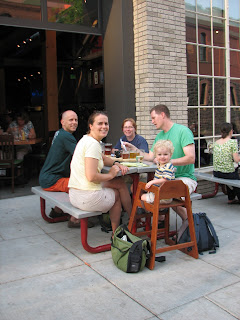
We hiked down, and met Kara and Allison back in the parking lot for a celebratory beer at about 6 pm. Then we all headed over the the Brewery one more time for a celebratory dinner. We all exchanged contact info, said our goodbyes, and crashed, our last night in Squamish. We love this place.

(Allison now:) Once the guys set off for their adventure, Kara took me to check out an area that Will and I had not visited yet called Smoke Bluffs. This is more mellow location with mostly single pitch climbs that are easily top-ropped. We both led Cat Crack and Corner Crack and then top-roped Flying Circus, a a great 5.10a crack with some fun finger jams. I don't think that I have ever climbed as many routes that required finger jams as I have here in Squamish. I've always avoided the finger cracks at T-wall (the Tennessee Wall in Chattanooga- our favorite local climbing area), but am now anxious to get up there and work on my technique.

Kara and I returned to the Chief parking lot in time to catch Will and Jon on top of the Sword pitch of The Grand Wall. We watched a bit and took a few pictures and then met back up with the guys back at camp. As we mentioned in one of our first blog entries, our trips are really made by the people we meet along the way. It was great hanging out with Kara and Jon.


July 8, 2008

This morning we packed up our tent and said goodbye to Squamish. We stopped by the Brackendale Bistro on our way out of town for a great breakfast and then hit the road. The plan was to make it to Glacier National Park by evening. The drive through the mountains was beautiful, taking us by Whistler (where we popped in for a second, but felt no need to stay) and through Garibaldi Provincial Park. We exited the mountains to end up in a terrain very similar to the high desert in Utah. Sage was everywhere, and it got quite hot, quite quickly. We hooked up with the Trans-Canada Highway and followed the Thompson River a little while until it became dammed to create a reservoir/recreational area similar to Lake Powell on the border of Arizona and Utah. This was not really where we wanted to hang out, so we continued east along the Trans-Canada Hwy. We pulled into Revelstoke, B.C. in the late afternoon and decided that we should go ahead and look for a campsite there so that we could explore the area in the morning. We found a great spot about 15 minutes north called Martha's Creek Provential Park.

This morning, we woke up and drove up the Meadows-in-the-Sky Parkway and hiked to the summit of Mt. Revelstoke. From the summit we could see panoramic views of the Columbia Mountains.

We left Mt. Revelstoke and continued east to Glacier National Park. The first view that we got driving into the park was of a range of mountains with razor thin ridges. They were incredibly striking, making us gawk like a couple of tourists...oh, wait, we are a couple of tourists. The rest of the drive was similarly gawk-worthy, arriving on the east side of the park only to be greeted by the Rocky Mountains.

So, here we are, sitting in an internet cafe in Golden, B.C. Oh, did we mention that our computer died on us? Yep, we'll be bloggin' from the cafes from now on. We're not having too much luck with our technology these days as Allison's cell phone was water-logged on our mountain biking trip, and there is no hope for reviving it. In any case, that's why we haven't posted many photos, and why we have not updated our flickr site. We'll work on that next time!

The plan now is to head to the Bugaboos tomorrow morning. We will be staying at the Kain Hut, owned and operated by the Alpine Club of Canada. We'll be in touch when we get out of the mountains.

Hasta Luego!

Saturday, July 5, 2008

Some of you have been wandering when we would update our blog next. Sorry...we had to wait for a rainy day at Squamish before we could hide away in another wireless cafe (or, in this case, wireless brewery.) In any case, here goes:

After a lazy morning of breakfast and blogging in Hood River, we headed to Portland, dropped off the truck for a few minor fixes, and then rode our bikes to meet up with Cory (a friend from Atlanta who moved to Portland) and Tara (Allison's roommate from college) and Colby (her two year old son) at a great restaurant called Por Que No. It was in a "transitional neighborhood" on Mississippi Ave. Great food and area. Then we took off on our bikes and explored Portland with Cory. Portland is such a bike-able city. You cross a main road every once in awhile, but for the most part, you are riding through neighborhoods. And, people watch out for bikers. Afterwards, we hooked up with Tara and Brian (her husband, and Will's partner in crime from our Africa trip) for dinner at Toro Bravo, a great tapas restaurant.

July 1, 2008

This morning, after breakfast, we took off to visit the fantasy world where Brian works, called Nike. It's really an amazing campus, with more than enough locations for running and walking, a whole soccer field, an indoor basketball court, spinning arena and even an indoor climbing wall.
On our way home, we got to visit the coolest playground imaginable in Washington Park. Who knew what treasures we would find by hanging out with a 2 year old?

The afternoon was spent among the millions of books at Powell's bookstore- Cory's place of employment. If you haven't been there, you must go at some point in your life. For dinner we were able to get all of our Portland friends together at Deschutes Brewery.
The evening was topped off with a hike through Forest Park, a beautiful green space not too far from Cory's abode.

July 2, 2008

The day started off early in an effort to catch the 12:45 ferry from Port Angeles, WA to Vancouver Island. Even after a few extended stops for road work, we made the ferry without any problem. We arrived in Victoria and headed to Allison's aunt Dabney's house. She has a home overlooking the Strait of Juan de Fuca and Olympic Mountain Range. Unfortunately, it was too cloudy to see the view, but we had visited about 5 years ago and knew what was behind the clouds. We had a fabulous visit with Dabney, getting a chance to walk around her beautiful neighborhood.

July 3, 2008

After a leisurely breakfast, we decided to hit the road for Nainamo, BC to grab a ferry to Horseshoe Bay on the mainland north of the city of Vancouver. The city of Vancouver isn't on Vancouver Island. It's so confusing! A relaxing and scenic ferry ride landed us on the road to Squamish, our first major climbing stop. Excitement building at this point. Entering Squamish we are greeted by a sign proclaiming it "The Outdoor Recreation Capitol of Canada". We got one of the last available campsites at the Stawamus Chief Campground, and then ran over to The Apron area, and ticked off Diedre (5.8), one of the undisputed classic moderate routes here. The guidebook says "The most popular climb on the Apron...subject to heavy crowding and lineups, unless you're willing to climb at night or in the rain." Amazingly, there wasn't a single party anywhere on the Apron. Apparently it had rained this morning, and the relatively late hour (about 3:30) probably helped. We polished off this fantastic climb, and the day was feeling like a coup on many levels. Walking into one of the most popular (and rainy) climbing areas on earth, on a Thursday afternoon, scoring a campsite, and having one of the most popular routes to ourselves. A great first day at Squamish.
We topped it off with dinner at the Howe Sound Inn & Brewing Company, with excellent food & beers. The restaurant has a huge mural of the Chief (the largest rock formation here, and center of the climbing) with routes marked. It's really fun to be in a place where rock climbing is such a part of the community. In many places in the states, the climbing community is constantly tiptoeing on thin ice, at odds with the communities where the best climbing exists. Not so here.

July 4, 2008

Slept in a bit and headed over to the base of the Grand Wall of The Chief. Eric (who we climbed with in Boulder) had recommended the classic finger crack "Exasperator". Of course, our late start meant that there were already some folks on the route, and others waiting to try it. No worries, there are hundreds of routes here, and we hopped on Peasant's Route, a 5 pitch 10c just 20 feet to the left. We'd read that the ratings were a bit soft here (a soft rating would mean that a climb of any given difficulty grade would feel a bit easier than it's rating). This was a chance to test that theory, and we're not so sure that we think the ratings are soft here. A great route nonetheless, and after a little waiting we ticked off Exasperator as well. Thanks Eric, an excellent recommendation! We cooked dinner on the truck tailgate in the parking lot, surrounded by other climbers doing the same.
The folks parked next to us saw Allison's Triple Crown socks (a prize from the southeast's Triple Crown Bouldering Competition) and asked where we were from. Turns out she'd spent some time in Atlanta recently, and had climbed at Wallcrawler, our gym on Dekalb Ave (for any of you that know Dave from the gym, tell him we met his friend Samantha). Small world, the climbing one especially. One of the things that I love about climbing is that you can be in the middle of nowhere, hanging off a cliff face, and discuss minute details about a particular section of a particular route that is hundreds of miles from where you are, and hundreds of miles from where either of you live. It makes you feel like part of something relatively exclusive.

July 5, 2008

The forecast called for rain today, and we indeed awoke to rain. It was relatively light, so we stopped into a bike shop for a mountain bike trail recommendation. We biked most of the route of the Test of Metal mountain bike race, which took place last week. About halfway through the ride the rain ramped up considerably, and we were cold, wet, and very dirty by the end of it. We went by the Squamish Recreation Center, which offers showers for a small fee, and a pool, hot tub, and workout facility for a little more. We opted for hot showers only, dropped our laundry off for wash & fold service, and headed back to the Brewery for lunch, where we sit and write this. Having a blast. Forecast calls for rain tomorrow morning, then better weather for a few days. The Grand Wall awaits...

Monday, June 30, 2008

In the interest of time we decided not to visit Salt Lake City. We stopped briefly in Green River, and later grabbed dinner at Rooster's Brewery in Ogden, then it was on to City of Rocks. City of Rocks National Preserve is a major climbing destination consisting of huge granite blobs, pretty much in the middle of nowhere in the bottom center of Idaho, near Alma. Getting there involves driving 25 or so miles on well maintained dirt roads, dodging giant jackrabbits all the way. We arrived in Almo at 11:00 pm, and stopped into the convenience store to try to buy a climbing guidebook for the area. They were all out, and informed us that the campground was full, due to some sort of festival going on here. They directed us to an "RV Park" just up the road. They told us that it was not maintained, and they didn't think anyone even checked the pay station. Indeed, when we pulled in it was competely deserted, and looked as if no one had stayed there in years. It consisted of leveled gravel pull-thru sites in an open grazing field. We fed the pay station the requested $10.00 anyway, and decided it was the perfect, quiet place to crash for the night.

The next morning we drove into the climbing areas, marveling at the enormous amount of climbing that must be here (we picked up a guidebook at the Visitor's Center on our way out, and there are over 750 routes listed). The blobs are everywhere. For the non-climbers, in the sidebar you will find a link to an abbreviated Glossary of Climbing Terms from the end of an old trip report. We had a look at someone else's guidebook, and chose a few climbs on Elephant Rock (recommended by Anne and Tom), namely Rye Crisp (5.8), The Pygmies Got Stoned (5.10a), and Columbian Crack (5.7). All were fantastic. The rock here is amazing, and the number of routes and close proximity campsites seem to make a future group rendezvous here essential. Anybody? We were on the road to Hood river by 11:00 am.

Saturday, June 28, 2008

Boulder

We rolled into Boulder on Wednesday evening and hooked up with Tracey at a great restaurant just down the street from her house, Centro. Bedtime followed soon after with plans to get up and climb in the morning.

June 26, 2008
On Thursday morning, we woke up and headed out for Eldorado Canyon. As on our previous visit to the Canyon, we marveled at the amazing little community of Eldorado Springs. It seems like quite an ideal place to live.

Our initial plan was to climb the Green Spur- on our last visit to Eldorado, we climbed a route called the Yellow Spur, possibly one of our favorite multi-pitch routes. We hoped to find the Green Spur a similarly spectacular route. We arrived at the base of the Green Spur to find a party of two at the first belay as well as a party of three slowly making their way up the first pitch. Therefore, Will decided that he should warm up on a 10c instead, Grandmother's Challenge. Allison started off by leading the first pitch (8), only to discover that she used up all of her gear before arriving at the belay. Therefore, Will took over and made his way to the first belay stance. The crux of the route was the 10c roof immediately above the belay. Will took off and pulled the off-width roof without much problem. Unfortunately, we can't say the same for Allison. (I'm blaming it on the top-rope pulling me off the route.) In any case, with a little help from Will, Allison made it up the route just in time to be greeted by a thunderstorm coming from the south. We decided to rap down and not risk the lightning. Of course, by the time we walked out, the sun was shining again.

We headed back into Boulder where we strolled a bit and then had a fabulous dinner- Will had paella cooked by a visiting chef from Barcelona.

June 27, 2008
One of the best things about our road trips is visiting our friends and hooking up with folks along the way. Two of our friends, Skip and Kelly have a conference to attend near Rocky Mountain National Park. They decided to arrive early- Kelly and Eric from Houston and Skip from Atlanta- and meet us for a little climbing. We hooked up early and hiked to the first Flatiron, barely 10 minutes out of town. The route was absolutely fantastic. Rated 5.6, the challenges were more mental than physical with the first two pitches being run-out slabs with great friction. We topped out at the first false summit and then climbed along the ridge to reach the real summit- at 1000 feet. The views were incredible. A highly recommended route.


After descending from the summit, we headed back into Boulder for lunch. Again, we found a great dining experience within a stone's throw of Tracey's house., West End Tavern. Talk about a great location.

After lunch we headed up to Flagstaff Mountain to check out the local bouldering. It was a little warm for bouldering, but fun to check out new areas.


The day's activities were wrapped up with a dip in the pool at Kelly and Eric's hotel. Then off to meet Tracey for dinner at Med before she took off for salsa dancing with her Boulder folks.

June 28, 2008
We decided it was time to stop lingering in the fairy tale town of Boulder and head on towards our next fairy tale town of Portland, OR. We are now heading in that direction with a few detours in Green River, WY, Salt Lake City, UT, City of Rocks, Idaho, and Hood River, OR. I hope we can do this all in two days!

Thursday, June 26, 2008

Days 1 & 2

06.24.08 Day 1
Our proper sendoff for any road trip has become breakfast at Ria's Bluebird in Grant Park, our favorite breakfast in Atlanta. Only 2 miles from home, already various allergies are clearing up, leading us to the conclusion that we must simply be allergic to not being on vacation.

Approaching Columbia, MO, we drove into some of the most menacing clouds we'd ever seen, and thought for moment we'd see a tornado first hand. I looked up just in time to see the last second of some ball lightning exploding in mid air. We had dinner at a bar in Columbia and retired to Katfish Katy's Campground, along the Missouri River. Their lower campground has been under water for a few weeks, but the upper one is fine, if a bit buggy. No matter, we're just here to sleep.

06.25.08 Day 2
About a mile from our campsite, between potato fields, stands the Missouri State Champion Burr Oak (pictured below). Last measured it is 84 feet tall, with a spread of 116 feet. Its trunk has a circumference of 272 inches at 54" above the ground, and it is about 350 years old. We breakfasted in its shadow, and began what will probably be the most boring day of driving on the trip, the long, straight interstate between Columbia and Denver. I maintain that playing though your ipod library alphabetically by song is usually more interesting than utilizing Shuffle.


We stopped at Grandma Hoerner's Foods, beside the interstate in Alma, Kansas, where they produce and package all natural salsas, jellies, juices, and other items for stores around the country including Trader Joe's and Harris Teeter. It was surprising that such a small operation could output enough product for big chains like these. We sampled and bought a lot of stuff.


At a fuel stop near Abilene, KS I photographed this hearse, painted like the General Lee, of Dukes of Hazzard fame. I was taking a picture of the side that said "Beads For Boobs -OR- Boobs For Beads" When the owner said "The other side's better. My goat ate up this side." so I moved around to get shots of the "FREE MAMOGRAMS" side. See our Flickr site for a photo of their buddy's trailer, painted with zebra stripes and labeled "BUSH WACKER" So far this drive isn't nearly as boring as we would've imagined.

We rolled into Boulder at sunset, with a beautiful view of Long's Peak. We met up with our friend Tracey, who moved here from Atlanta 2-1/2 years ago. We'll be staying with her for a couple of nights.

Sunday, June 22, 2008

Accessorizing our "Mobile Home"

Installing Dome Lights

Making Curtains


Saturday, June 21, 2008

Canadian Rockies Summer 2008

Gas prices are rising and there seems to be no end in sight, so why not take a trip across the country? This summer we're heading to the Canadian Rockies to do a little climbing in Squamish, the Bugaboos, Yamnuska, Banff, and a few other places. We've decided to send out our trip reports via a blog- yep, we're venturing into the blogosphere. This gives you the option of checking in on our travels whenever you want...or not!

Below is a tentative itinerary for our trip. Feel free to pass along any recommendations of places to stop and check out along the way. Also, we are not quite sure how we are going to get from the Canadian Rockies to Minnesota, so any recommendations there would be welcome as well!


June 24
Head out of town!
June 27 - 28
Boulder
Eldorado Canyon
June 30 - July 2
Portland, Oregon
July 2 - 3
Vancouver Island, BC
July 4 - 8
Squamish, Vancouver, & Skaha
July 9 - 10
Glacier National Park
July 11 - 14
Bugaboos
July 15 - 21
Bow Valley; Banff, Yamnuska, Jasper, Lake Louise
July 22
Calgary
July 25
Edina, MN
July 27
Home